7/10/2014

ÉDITION 2014 DU SEUL ET UNIQUE UNTAMED NEW ENGLAND


Album photos sur FB: http://on.fb.me/1zs8kKA

Notre équipe @ Untamed New England 2014
Alexandre Provost
Jean-Yves Dionne
Stéphanie Lajoie
Jonathan Dionne

Après plusieurs mois en dents de scies pour un peu toute notre équipe (repos post ARWC Costa Rica, reprise de l'entraînement difficile, déménagement, changement dans notre équipe) nous étions enfin arriver à notre objectif commun, Untamed New England.

Les trois gars nous étions super contents de pouvoir compter sur Stéphanie dans nos rangs. Après quelques petites courses et autres activités de préparation, nous nous sommes tous retrouvés à Northern Outdoors pour l’événement de l’année. C’est toujours cool de se rejoindre tous la bas les amateurs de raid aventure, c’est comme si on envahissait l’endroit. Nous sommes toujours reçu de belle façon.

Mardi 17 juin - Veille de la course
Tout se passait à merveille jusqu'à ce que on se rende compte à seulement quelques heures du race briefing que 2 rayons étaient cassés sur la roue avant de Jonathan. Après quelques appels, JY doit se rendre à Farmington, ME qui est à plus de 100km au sud de The Forks faire réparer… Il revient juste à temps pour la photo de Luis Moreira et on respire alors mieux. Grant et son équipe nous présente alors un aperçu vidéo du parcours qui a l’air dantesque… et nous obtenons enfin les cartes. Nous avions déjà le survol du parcours afin de pouvoir préparer notre matériel à l’avance alors quelques derniers préparatifs et on réussi à se coucher vers 0100.


Mercredi 18 juin - Race Day!
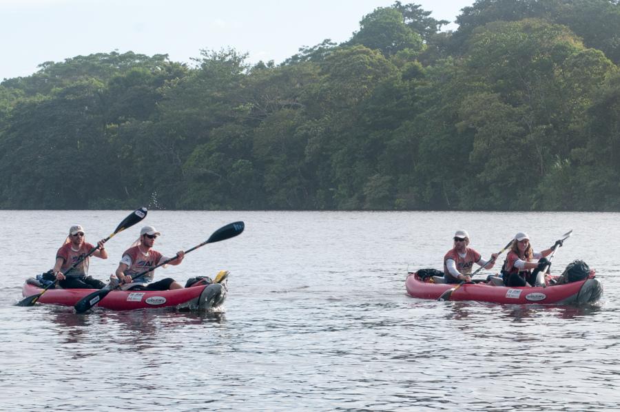
Canot & Trek
Le départ est donné pour un prologue sur les rives de Moosehead Lake. On part avec le groupe et nous revenons aussi avec le même groupe de tête. Pas très compliqué mais pas simple non plus car plusieurs sentiers ne sont pas sur la carte additionnelle qui nous sert également de carte de pointage pour ce prologue. Il s’agit d’une boucle, et une fois les 3 CP terminé nous revenons vers le départ pour y prendre les canots. toujours avec les meneurs, on met rapidement à l’eau… pour se rendre compte 10 minutes plus tard que dans la cohue générale du 3e CP du prologue/remise de la carte de pointage/prise des embarcations nous n’avons pas poinçonné CP1 qui était sur le bord de l’eau… nous n’avons d’autre choix que de rebrousser chemin pour aller poinçonner.


On pagaie bien et on reprend pas mal d’équipe en direction de CP2. On court ensuite vers CP3 qui est le sommet du rappel car on sait qu’il y a potentiel à y avoir de l’attente au sommet des cordes (bien qu’on nous ait assurer l’inverse…). On arrive au sommet en 11e place et nous constatons que toutes les équipes sauf les 3 premiers y sont toujours. Après pas loin d’une heure d’attente on fini par faire notre rappel. Au moins la vue est superbe et Vladimir Bukalo y est pour prendre des belles photos!

Lorsqu’on bouge on bouge rapidement et de retour sur l’eau on arrive vite à CP7-8-9. Nous reprenons un peu de terrain sur les équipes devant nous (Dart Nuun et UNE-MadAthlete.com).


La traversée de Moosehead Lake se fait bien avec un bon vent de dos où nous décidons de sortir nos voiles Windpaddle et ça va super bien! on surf même quelques vagues! On les garde pendant au moins 45min où Steph et JY qui sont à l’avant dans chacun de nos 2 canots ne tiennent que la voile. On calcule aller pas mal à la même vitesse, mais avec 2 pagayeurs en moins c’est de l’économie d’énergie!

Vélo de Montagne
On arrive à TA1 au crépuscule et une transition rapide sur les vélos nous envoi dans la nuit en 10e place à la chasse aux équipes devant. On roule super bien et on rattrape 3 équipes en route vers CP14. L’approche vers CP15 n’est pas clairement définie sur la carte avec un bon gap de presque 1km où il n’y a pas de sentier. Cependant, une bonne exécution nous permet de trouver le sentier qui nous mène à la route sur col et l’opération nous fait gagner quelques place sur nos rivaux (on voit des lumières dans la forêt). Nous arrivons à CP18 au superbe AMC Gorman Chairback Lodge à l’aube pour le relais d’orientation où chacun doit effectuer un parcours d’orientation en solo, nous sommes en 5e place. Nous avons eu une excellente nuit (à part que Alex a manqué de lumière pour un bon 2h) et tout le monde va très bien.

Jeudi 19 juin
Relais d’Orientation
Chacun y fait de son mieux pendant que les autres se reposent un peu. JY, Jo et Alex s’échange la paire de soulier de course (nous n’en avions besoin qu’à cet endroit à tour de rôle alors une seule paire suffisait!) On arrive par contre pas vraiment à dormir avec le bruit. On repart en 6e place après avoir fait le relais et le plein de crêpes!

Packraft et Trek
On reprend où nous avions laissé en vélo de montagne et nous enchaînons rapidement jusqu’à TA2 pour passer du vélo de montagne à la section cruciale de la course, soit celle nommé ‘Abenaki Lost World’. Nous quittons le TA en même temps que RIG-Xact Nutrition et UNE-MadAthlete.com. C’est une section à pied et où à certains endroits on va devoir gonfler les Alpacka Gnu pour aller chercher certains CP. On met à l’eau et on part vers une belle section nautique. Nos Alpacka Gnu nous servent bien car sur Third Road Pond le vent de face est si fort qu’on a de la difficulté à avancer. On s’en sort encore bien et nous atteignons CP32 sur le First Roach Pond après une traversée des plus houleuse! Surfer en packraft: check! De la débute le super trek annoncé. C’est la fin de la journée et nous savons que nous aurons à dormir un minimum durant la nuit à venir afin de rester alertes. Nous avançons toujours bien et nous pensons être qqpart entre la 4e et la 6e place. On doit porter à peu près tout ce qu’on a y compris nos 2 Alpacka Gnu, nos veste de sauvetage, nos pagaies et nos casques en plus du reste. Inutile de dire que nos sacs sont lourds comme jamais. On a cependant une autre carte cachée, soit les sacs à dos poids plume et hyper-résistants Windrider 3400 de Hyperlite Mountain Gear. Ils sont assez grand qu’on y met tout dedans, donc rien à l’extérieur pour  s’accrocher dans les branches. Et des branches… il va y en avoir beaucoup au pouce carré...


CP33 se passe bien, on redescend sur le chemin vers CP34 pour une attaque toute en montée. C’est plus facile de garder un azimut lorsque le terrain est à niveau, que ce soit plat ou en montée/descente. CP 34 se passe bien aussi. C’est très garni mais on arrive à bouger quand même. On redescend et on croise UNE-MadAthlete.com et O-Store.ca. Notre rythme a diminué et c’est signe qu’il faut dormir un peu. On se rend jusqu’à notre point d’attaque sur le sentier à 2160’ et nous y allons d’un power nap de 30min. On ne monte pas la tente, on se couche simplement par terre. On s’endort instantanément et 30 minutes  plus tard le cadrant sonne… toujours difficile de repartir mais c’est incroyable comment 30 minutes de sommeil en 2 jours peut faire du bien! On part alors dans la montée vers CP35. C’est de plus en plus garni et on se retrouve dispersé. C’est un des pires bushwack de notre “carrière” en raid aventure tellement c’est difficile de garder un quelconque mouvement progressif. En arrivant près du col, on pense alors être à l’Ouest de Lily Bay Mountain et nous continuons donc à monter vers l’Est… on se rend alors compte de notre erreur au sommet qui est à 1.5km à l’Est de notre objectif. Damn! On se réajuste et on repart vers CP35. On a un peu le moral à plat à ce moment, car on sait que nous venons de laisser 2h de dur travail sur la table. Oh well, toutes les équipes font des erreurs… mais c’est dur de se sortir ça de la tête. On ressort finalement du bois sur un sentier qui nous mènera à la transition. O-Store.ca est juste devant nous, alors on se met à courir en descente. Pas le choix, même si les sacs nous pèsent de plus en plus. Arrivés à TA3, on nous apprend que la section nautique qui devait avoir lieu est maintenant remplacée par du vélo de montagne pour cause de fort vent sur le Moosehead Lake. Pas de misère à le croise… On se rend compte aussi que malgré notre erreur, nous sommes au plus fort de la course, ce qui nous redonne un boost. Une bonne transition nous fait le plus grand bien et on se dirige donc rapidement vers Greenville en MTB pour le Urban-O.

Vendredi 20 juin
Vélo de Montagne
Orientation urbaine dans Greenville, ME
On a une super section, on est léger car étant donné que c’est un boucle on a pu laisser le matériel non requis au départ de la celle-ci. On arrive et repars en 1h20m. Il y a un kiosque de panini sur place, et on s’assure de faire le plein. Ça nous redonne de l’énergie et nous repartons à pied pour un trek d’environ 20km qui monte jusqu’à 3300’.


Nous croisons O-Store.ca vers CP40 et pour des raisons obscures nous nous laissons déconcentrer pas leur présence. Un marquage plus ou moins bon sur notre carte nous cause aussi du tord et nous voilà en train de chercher le CP40 environ 800m trop tôt. On essai de faire du sens de tout ça, l’équipe Raidlight  (et d’autres sur des parcours alternatifs) nous passent. Après un autre 2h de “viraillage” on raisonne enfin convenablement et on trouve le CP en 10 minute. Décevant mais c’est la vie. Nous avons par contre perdu contact avec la 4e place et une équipe nous a passé, donc nous sommes de retour en 6e position.


Nous exécutons bien la suite et nous arrivons à passer Raidlight peu de temps après dans la forêt. Le poids des sacs se fait sentir dans la montée et la descente de Big Moose Mountain. La vue au sommet y est superbe et on voit une bonne partie du chemin que nous avons parcouru, impressionnant. Nous redescendons dans les pistes de ski, c’est une ancienne station.

Nous arrivons à TA4 à la base en fin de journée pour reprendre les vélos. Nos amis ActiveSteve, Tessa et Nicky de BreatheMag.com y sont, c’est toujours agréable de voir les amis sur le parcours.

Vidéo @ TA4


Vélo de Montagne
Nous nous sentons encore tous bien mais nous sommes 1h45 derrière O-Store.ca et Raidlight arrive 30 minutes après nous au TA. Nous n’avons donc pas de temps à perdre et la 4e place est toujours à notre portée devant. Notre transition n’est pas des plus rapide par contre.

On nous remets 2 CP additionnels à cet endroits et d’après ce que nous apprenons des autres équipes, le CP43B est particulièrement cauchemardesque. On planifie une approche plutôt conservatrice qui nous ramène à Greenville via la route pavée donc très rapidement. Nous prendrons ensuite Dyer road. C’est plus long en distance mais plus sûr et c’est maintenant la 3e nuit donc nous commençons à être bien “attendris” comme on dit. On exécute bien malgré qu’on aurait aimé aller plus vite. On vote pour un autre 30 minutes de sommeil pour que tout le monde reste “sharp”. On a un super spot sur un cap de roche. On repart ensuite et avec un bon tracking on arrive à CP43 en un bon temps. On garde un bon train jusqu’à CP44 où nous savons que nous allons devoir nous arrêter pour le reste de la nuit puisqu’il fallait être arrivé à cet endroit avant 1830 pour poursuivre sur la section de rafting. Nous y arrivons à 0158. Columbia Vidaraid y est arrivé en premier à 2012, donc aucune équipe n’a pu faire le barrière horaire. Nous sommes donc en 5e place.

On monte donc la tente pour une nuit (inespérée en course expédition) mais toutes les équipes devant vont aussi se refaire donc le classement sera difficile à changer demain… On prend le temps de manger et boire avant de se coucher histoire de reprendre des forces.

Samedi 21 juin
Rafting
Le sommeil nous a fait le plus grand bien même si JY au réveil se demande qui lui a passé un papier sablé sur la langue durant la nuit…


Il y a un race briefing à nouveau en matinée, nous partirons sur la Kennebec avec un guide de Northern Outdoors pour un bout et nous continuerons sans le guide sur une section plus calme jusqu’à The Forks pour le CP45. La rivière est superbe, vraiment une des belles rivières à rafting dans le Nord-Est de l’amérique. On part sur la Kennebec River en 5e place vers 1030.

Trek & Packrafting
C’est devenu une course d’un jour car les écarts sur la route on été annulé par le “dark zone” de la veille (les écarts réels ont été maintenu évidemment). Une fois arrivé à CP45 on y laisse le raft et nous repartons à pied avec toujours tout le matériel (que nous traînons depuis TA2...). L’équipe suédoise Sweco est derrière nous au classement d’environ 1h mais nous ne voulons pas qu’ils nous passent. Il nous rattrapent par contre vers la fin du trek vers le premier CPA sur la Dead River. Nous sommes ensembles à cet endroits et nous descendons à la rivière. Ils repartent un peu devant nous. Le packraft sur la Dead River est bien amusant mais ce n’est pas la tasse de thé à Steph. JY et Jo se débrouille bien malgré une petite fuite de leur embarcation. On doit s’arrêter plusieurs fois pour vider. Nos Alpacka Gnu font une super job et on récolte les deux CPB-C en descendant la rivière.


Packrafting sur la Dead River:


Vélo de Montagne
Sweco est à CP46 qui est au même endroit où nous avons débuté ce trek plus tôt dans la journée. On prend alors les vélos de montagne pour la dernière section (1 CP) qui nous ramènera à Northern Outdoors. L'excitation est palpable car nous les avons perdu de vu et bien que la 4e place ne soit probablement plus possible, nous tenons fermement à assurer notre 5e position. Après quelques essais non fructueux nous trouvons le chemin voulu et nous sommes finalement en route pour la dernière montée de la course vers le dernier CP. La descente est assez mouvementée avec des grosses roches mais nous la négocions bien et nous arrivons enfin à Northern Outdoors!


La ligne d’arrivée est magique, soleil de fin de journée, il y a plein de monde, de la bière et on peut enfin s’asseoir! On nous confirme notre 5e place! 5e contre des équipes aussi fortes, c’est au delà de nos espérance!

Le sentiment d’accomplissement après ces défis est difficile à décrire. Un mix d’euphorie dû au manque de sommeil, de joie de terminer avec une bonne performance, de délivrance parce que il vient un moment où trop c’est comme pas assez, de fierté d’avoir accompli notre objectif mais aussi un soupçon de déception que ce soit terminé. Il y a souvent un moment dans les courses où on se dit “c’est la dernière…” mais c’est bizarrement oublié une fois passé la ligne d'arrivée. On oublie vite.


Nous avons eu au final une super course les 4 ensembles. Nous remercions tous ceux qui nous aident et rendent ces aventures impossibles possibles, soient nos familles et amis, les organisateurs et leur équipes de bénévoles et nos commanditaires. Merci à tous.  

Félicitations à toutes les équipes, de la première à la dernière.

Thank you Grant!

Crédits photos: Luis Moreira, Vladimir Bukalo et Troy Johnston


Interview de notre équipe au fil d'arrivée:


Vidéos récapitulatif d'après course:


Randy Ericksen:

4/17/2014

COSTA RICA ADVENTURE RACE - ARWC 2013 VIDEOS

Costa Rica Wild Racershttp://vimeo.com/85500636 (44:00)
@ 10:43 we are changing a rear wheel flat tire on the first bike leg

All following videos are from Martin Papalia from PC-CAMP - http://pccamp.tv/

ARWC 2013 chapter #1http://vimeo.com/85879440 (07:14)
Previous Days

ARWC 2013 chapter #2http://vimeo.com/87178120 (08:58)
Start line in Panama Border
Pacific Ocean
Manglares de Sierpe

ARWC 2013 chapter #3http://vimeo.com/89130236 (09:38)
Talamanca Chain
Pacuare River
@ 00:50 we can see our team on the early slopes of Cero Chirripo

ARWC 2013 chapter #4http://vimeo.com/92030345 (07:02)
Atlantic Ocean
Nicaragua Border
Finish line
@ 01:29 our team closing on CP42 on Lagunas del Tortuguero
@ 02:07 JY CP42
@ 02:45 leaving CP 42 and briefly trying our sails

Team Tecnu Adventure Racing @ ARWC 2013 http://vimeo.com/86245201 (21:31)
@ 09:13 Nath taking care of her feet at mid-camp in San Gerardo

1/18/2014

MUD, HEAT, SUBMARINE CP, ALTITUDE, CROCOS AND BIKE WRECK


This is our ride at the 2013 Adventure Racing World Championship in Costa Rica


Team #16 - Untamed Canada / Clinique du Pied Équilibre
Alexandre Provost
Nathalie Long
Jean-Yves Dionne
Jonathan Dionne


What is adventure racing? Please see adventure racing definition on Wikipedia for more details if required.


Breathe Mag race description


2013 ARWC - Costa Rica Adventure Race
Trekking: 150km - 19%
Mountain Biking: 392km - 49%
Kayaking/Rafting: 262km - 32%
Total distance: 804km
Total ascension: 10562m
Total descent: 11600m

Here is our race story of what was arguably one of the toughest expedition races in ages. We knew it would be extremely hard and equally beautiful as it was announced as “815km of life time experience”. It surely was.


Landing in Costa Rica
After several months of preparations that included: months of training; many multi-day races and loads of emails, we were finally there, touching our goal when we boarded on our respective flights. Luckily we all landed safely in Costa Rica with all our gear in perfect working conditions. We arrived 5-6 days in advance to make sure to relax, shop for food and manage whatever we would need to manage. It may seem a lot but time always flies and we needed to rest before heading out onto the adventure of our lives.

We stayed at the San José Radisson (race HQ) close to the city center. It felt a bit ghetto as San José, at least the centro, is not made for bikers...! Even walking was sometimes sketchy as there is not much room on the side of the streets. We managed to pick up food and last minute gear without damage. The hotel itself was nice with spa/swimming pool, friendly staff and good food.


Race briefing, national flags parade and crazy fireworks
The full course was unveiled at the race briefing on November 30th after that we got a good hour of briefing on snakes... Bottom line, if we got bitten, we needed to call for help and fast. We took a very good note of that.


Next on the activity list was the national flag parade and opening ceremony. Part of that was the most insanely low and intense fireworks we had ever seen! I was praying we would not get hit by any debris...


With all infos at hand it was finally time to pack our gear and bike boxes for good. It may sound like an easy task but with many transitions areas (TA) and weight restriction (35kg/box) it can be a real Tetris game to fit as much food and gear in the right box for the right TA. Nath was very efficient overseeing that we were putting our things at the right place. Finally, we were ready and eager to get going.


GO TIME! December 2nd - 2:00pm


Day 1
A very warm Le Mans start in Union close to Panama border, near the town of Sabalito. It felt great to be on the starting line with all these teams from around the world. We ran for our bike boxes for about 1km to assemble our bikes to get going on the first section. We also got the first set of maps (we would get the maps in 3 sets during the race so the course was being unveiled as we progress). We had a rough start with 4 flats in the first 4h of racing. We manage to stay calm and repaired quickly every time. With the help of other teams (we had ran out of spare tubes) we managed to get going but we were a bit far back.

From CP3 near Miramar, the mud fest (a recurring topic in this race) started when we had to push, tow and carry our bikes uphill through some really muddy and narrow trails. We made it in good time to CP6/TA1 (near Pueblo Nueyo) after all. This bike leg certainly had set the tone for the rest of the race in terms of challenge. A long CP6/TA1, where we took the time to wash our bikes, got us in the boat for the first time on Rio Coto Colorado and on Golfo Dulce.


Day 2
CP7 was done at low tide in some really deep mud, we tagged a bit with team Issy Aventure in what would be the appetizer for the subsequent mangrove section. At least we had enough current to paddle from CP7. Then started a long and slow 45km paddle fest where targets would stay in front of us and closing very slowly. There was a shower by the shore at CP10 and we made sure to wash ourselves quickly before paddling to the end of this leg in Rincon for CP11/TA2.
 
We had a stressful episode then when Nath had to get a shot of antibiotics for a rash (her upper body had turned red in many places) and had to lay down a few minutes. I also got bitten in the eyelid, but everything was ok in the end and we left on the 27km trek with all our paddling gear (except the boat itself) looking to sleep on the way to CP12/TA3. Jonathan, our official translator (Jo speaks Spanish perfectly - a crucial skill for this race as local knowledge would turn out to be very important given the inaccuracy of the information on the maps) found a bar on the way, which in retrospect was a bit noisy... but at least we got to sleep 1.5h on a solid floor with a roof over our head (which ranks pretty high according to expedition racing standards).


Day 3
Sleep counter: 1h30m
We picked up our inflatable kayaks again at CP12/TA3 only to portage them for a solid 10km. We had a portage cart provided by NRS. There is not much to say besides that carrying 57 lbs boats was just really tough, in any manners. JY and Jo pulled a lot of efforts to pull us through. After some time searching we finally located CP13, filled our water containers as this would be our last source of fresh water for some time and went on the first epic section of the race, and one of our favorite, the mangrove “Monster”.


We had to work very hard against the tide for CP14, basically going up stream for 2km. We were with a bunch of teams and we detached ourselves when we picked up the right channel. CP15 was a in a small channel and we had to search for some time to find it. We met with teams that had been looking for several hours. All we can say is that some teams play dirty as a team was hiding CP15 in the water when we passed... but we saw the whole thing. There were teams everywhere, and we resumed our way. We connected with a bunch of teams in the small channel that was supposed to be the passage from CP16 to CP17. It was a dead end at low tide, we checked if the mangrove was “passable” but that would not have been a good idea (we would still be there…). We elected to sleep in our boats and we racked a solid 2h15. We then decided that waiting for high tide was not the best strategy and I was very doubtful that we were at the right place. Thanks to Nath’s hawk eye we found the channel going north toward CP17 just on our way out. We got CP18 but then we lost a bit of ground as navigation was tricky heading south but finally got the right track and made our way toward CP19. It took us a good hour to figure out what was going on there… you can take a look by yourself:


I think it is closing on CP20/TA4 that I remember thinking that we were now on the morning of day 4... and that we had covered only ¼ of the race in terms of distance...


Day 4 Sleep counter: 3h45m We picked up our bikes at CP20/TA4. We biked/pushed up the insanely steep hill while being cooked by the sun to get to the Superman Osa, a 2km zip line with speed above 100km/h. Crazy ride! The rest of this mountain bike section was simply beautiful. I said to JY many times that this was how I had envisioned racing in Costa Rica - magnificent views of valleys and mountains.

That night was not our best, with issues to locate CP25 and then CP26. We were all getting quite tired and finding the right path to CP26 from the ridge proved to be very tricky. After some time trying things that turned out to be unsuccessful, we opted to sleep for what was left of the night. In a matter of minutes we were then back on track with daylight on our side, which proves again that it is most of the time better to bank sleep than battle in vain during the night. On the way to mid camp, we collected oranges straight from the trees while riding near Angostura, so cool.


Day 5 - Mid camp
Sleep counter: 4h30m
We arrived at mid camp (CP27/T5-CP28/T6) in San Gerardo in the afternoon of the 5th day for our 4h mandatory stop. This was a real oasis with shade, food and our gear. We ate, showered and slept (2h) as one of the toughest section of the race was right ahead of us, the 92km high mountain trek. We were all in relatively good shape and high spirits even if we were lower than expected in the rankings (22nd coming in mid camp).


CP29 was located at the base of Cerro Chirripo in a large cabin (3400m). We made our way up there in good time even if we felt the altitude was slowing us down a bit. We slept again as our sleep bank was still very low given all the race still ahead of us. We racked 2h45m but strangely this was not our best sleep as the humidity in the cabin made it for a very cold one. We summited Chirripo in pitch dark. Cerro Chirripo is the highest peak in Costa Rica at 3820m of altitude. We went on toward CP32 with a fantastic sunrise over the ridge.


Day 6
Sleep counter: 9h15
The way down the high mountains was a native trail in an Indian reserve, Costa Rican jungle at its best. The trail was literally a mud slide all the way down the mountain, crazy. We thought we would be able to move faster after the rocky ridge but we were going twice slower. Tough section for our team, we helped each other as we could and finally made it down.
The next night was a hard one on our spirit. We had a rough time locating the path to CP34 and ended up bushwhacking in some very dense jungle. Not a great idea as it is very dangerous and utterly slow. We finally found our way and elected to sleep by the river in our mandatory shelter (1h30). JY even made a fire, a real camp site!


Day 7 Sleep counter: 10h45 In a matter of minutes of daylight, we were again back on track hitting the trails and the rest of our journey on this trek went well. We tagged along on and off with team GearJunkie/Yogaslacker. We completed our 92km quest with the sunset on the 7th day. An epic trek that saw us traversing high mountain range, authentic jungle and native villages. Engraved in our minds.
There was a mandatory 1h stop for medical check at CP36 in Paso Marcos. This was a very wise initiative from race organisers to make sure everyone was fit to keep racing after the mammoth trek. Again a small oasis with real food.

Shortly after we got to CP37/T7 (Bajo Pacuare) to finally get off our feet and hop on the bikes for a relatively short leg (40km) to the first rafting section. Before being able to leave we found that somehow Nath’s front wheel was not in her bike box and had been left at the previous TA (mid camp). Wisely I must say, we had another front lefty wheel and 26” tire, so we mounted it and we were able to keep going, although without a front brake for this section. The length of the race and sleep deprivation started to hit us harder in this leg. We stopped on a church front porch for a 25min power nap in Mata Guineo as the clock was ticking on us. JY in particular fought it hard and we finally made it to Tres Equis for CP39/T8 in the early hours of the morning after scrambling a bit to find CP38. The last part of the ride was particularly beautiful with intense colored flowers and lush green vegetation all over the place, amazing scenery.

Day 8
Sleep counter: 11h10m
We left CP39/TA8 in Tres Equis on foot for the rafting section. Costa Rica is internationally known for pristine rafting rivers. We were now on Rio Pacuare for some of the most beautiful rafting ride I have ever seen. It’s hard to explain but all this is a bit blurry in our minds as we had a really hard time staying awake, even in R4 rapids. We tried taking turns at sleeping at the bottom of the boat but the ride was too bumpy. “Zombie Rafting” made it for some of the most intense laughing episodes we ever had. Poor Walter, our guide. He worked a hard one with us!


Somehow… we made it to CP41/T9 without falling out of the boat. It is unclear for us how long we actually slept, but I am adding 45min to the sleep counter. We reunited with our beloved inflatable kayaks and it was time for the longest paddling leg of the race, a 89km journey from Siquirres to near Tortuguero. Still on Rio Pacuare there were yellow crocos glowing eyes all over the place… We used the current to keep moving taking turns at steering the attached boats while 3 of us where sleeping (I’m adding another 45min to the sleep counter). We did not want to sleep on those shores…


We connected with the canal shifting northwest toward Estero Parismina. We were still fighting sleep monsters and had to settle for a 45min nap. Again there were crocos eyes around so we tried to choose our place wisely we were now against the current. When I woke up I could not see JY/Jo's boat… I was shouting at them but no answer… quickly we started paddling downstream… and saw them slowly moving down 50m below! Ouf! Somehow they had lost their anchor. Lagunas Del Tortuguero was then just a long drag up to CP42 where at least we got a cold drink and a few nice pictures!


The canal leading to CP43/T10 was amazingly beautiful with jungle and wildlife all over with howler monkeys filling our ears. We left on foot for a short trek mostly on dirt roads leading us to CP45/T11 to get our bikes. While at the CP we heard that the 6pm cut-off for the next day had been extended... Again fighting sleep monsters, we settle down for 45min nap in a very nice garage on the bike ride as rain was breaking the sky.

Day 9
Sleep counter: 14h10
The rest of the ride was a tough and strange one. Maps were hardly making any sense, so we had to track every move to make sure we were going in the right direction. Obviously it was getting harder to do entering the 9th day of non-stop racing… JY bike was now in a dangerously degraded state and we had to make it into a single speed but it was barely holding together. Further down the road, my rear tire exploded… Thanks to Czech team Salomon-Suunto/Nutrend/S21 for lending us a tire (yeah, a tire). After a very rocky ride, we crossed Rio Sarapiqui for CP47 in Trinidad near the Nicaragua border. The way back south to the infamous CP48 was as rocky as the way up in many ways. Nath was having issues with her bike as well, and then we got into the ‘CP48 area’. After a bit of time looking around Jo and I managed to find the CP but it was now passed 6pm (official race cut-off). We texted the race management using the provided Delorme device from Pinnacle Tracking.


We received a positive answer as we were on the way to CP49-50/T12. Finally, the puck was rolling for our team. We happily reached the finish line, after 4 great but in the dark zip lines and yet another “Zombie Rafting” ride (+45min to the sleep counter) at 1h30am on Thursday December 12th as the last full course team. Hell Yeah - we did it!


There were many talks about the race being too tough and too long. That was the Adventure Racing World Championship - it had to be the toughest race of the year, in years. That said, there has to be something for every level of racers in these events and contingency plans have to be in place to make sure that teams that do not make cut-offs are able to keep racing on alternate routes and still reach the finish line.

Adventure racing is the toughest sport there is, and no obstacles can make it for what challenges nature has to offer. It was truly a great race. In our mind the organizers delivered everything they advertised, a grand race course that was indeed the adventure of a life time. We enjoyed every second of it.

Stats
Official 21st out of 67 teams - Leaderboard
Race time: 229h13min
Sleep time: +/- 14h55min - See sleep split details
Our GPS trace: http://bit.ly/1hTSzVL


Pictures and maps


Thanks
To all local people that were so kind and helpful during the whole journey, helping us out by lending their garden hose to fill up our water bottles and wash our bike when we could not pedal anymore, and allowing us to nap in their garage in heavy rains.


To Pongo, Antonio, Johanna, Patricia, José and all volunteers and rest of the organization for coming up with such an amazing journey. All the best for your next endeavour.

To our sponsors for making this possible:

To our gear partners to provide the best gear on the market:


And finally, thanks to my teammates for following me in these crazy adventures.

Alex
@alexprovo