I had the Equinox Traverse in mind since I saw team Tecnu in action last year. It seemed to be a good challenge in an area that I like a lot with the Appalachian mountains, many great rivers and even tropical vegetation in some places. It's such a fantastic playground. Quite different than black spruce bushwhacking! So at some point I submitted the 'ET project' to the team. At about 1000$ for 2 days of racing, Equinox Traverse is surely one of the best deal out there, and the driving/racing ratio was well on our side with 10h of driving for 46h racing, so it totally worth it. It did not take long for the race to be marked and highlighted on our race calendar. There are not many opportunities to get over 2 days of non stop racing, so we were looking forward to get some quality racing under our belt and place a pivotal brick in the master scheme of our season.
Racers: Alexandre Provost, Jonathan Dionne, Nathalie Long, Jean-Yves Dionne
At 7am on Thursday July 11th we took the early best decision of our week-end: we changed the wobbly bike rack that was already in doubt when we got out of the parking for a solid one - Thule of course. The only thing was that we had to unpack and repack the car to put one bike inside. Within 20 minutes we were back on the road with peace of mind and with a good Tetris effort we even had as much room as before!
12 hours later and we were very happy to arrive at Ohiopyle state park and finally stretch our legs from a long road. Got to HQ at Wilderness Voyageurs, met with Doug and crew and got the maps. Everyone over there seamed happy and relaxed, good vibes.
Race course: Rafting - Trek - Rappel - Trek - Bike - Trek - Bike - Kayak - Trek - Bike - Trek - Bike for about 164.4 miles of ‘fun’...
Friday morning while leaving our cozy 'Hummingbird Nest' where we stayed for the night, we noticed that JY’s front wheel shaft was not in good shape (hub). After a few tries and evaluating different options, we had to settle for a last minute bike change and rented a bike (thank god there was a decent bike shop around). A good team effort got us ready in 15 minutes, but not without a good amount of unnecessary pre-race stress. The second race saving decision in less than 24h. Already on a roll!
Race on!
The race started around 10:15am on July 12. The rafting section was fun, and knowing how much biking and trekking still to come, we really wanted to hammer this section to get started with the real stuff as quickly as possible. We would not need our arms again for the next 24h or so anyway. Races are never won/lost in rafting sections, it's more of a reward and fun time to kick start things before the real fireworks. Our guide did a great job and we managed to do well and our boat was second out of the water only seconds behind the first bunch. We then stretched our legs on a good run first flat and then up and down that eventually got us to the rappel (CP2). We were happy to be there in first, given we made a small detour (which reminded me to take the extra second...). Nice overhanging rappel down a bridge!
.jpg)


After a short trek coasteering beside the river we got to TA2 where our bikes awaited our butt. They (our butt) did no know what they were in for at that point... SOG and Rev3/MK got in the TA not long after but got out before us as we took a few extra seconds to make sure we had everything. After all this was the only TA with gear/food access for the next 22h so it was very important to make sure of everything.


We caught up with the leading pair SOG - Rev3/MK shortly after the TA. We had a good rhythm and we all new that the fight would be a long one. Like it's often the case when 2 or 3 teams are moving together, we all over shot the trail leading to CP5. I had a hunch when I passed it but I also felt that Dan from SOG had some kind of local knowledge so I decided we should to stay a bit more on their wheel. We realize it soon and got back to the right spot in no time, no big deal. Then on the way out Nathalie's rear wheel slipped on a wet log and she fell hard on her right side, injuring her right scapula... we held our breath for a few moments, but she fought it hard and we resumed our ride to the next CP (not without pain). As a real fighter she toughed it up and endured the pain for the rest of the race.
Choosing a different route
Back with the leaders, it got interesting as we split up for our approach to CP6. "HAHA! now the fun begins!" I remember thinking. There was a trail on the Ohiopyle park map that seemed to allow us to skip some up hill trail riding for some shorter dirt road up hill riding, which made sens for us. The only thing is that we were not 100% sure that the trail was there as it was not the topo... Still, we decided to stick to our plan and take 'Lytle road' in our approach. It turned out the trail was there up to a point, but soon we were pushing our bikes. After unsuccessfully trying to follow some kind of trail markers, we just decided to put the hammer down and bikewacked up hill in the thorns. We were committed anyway at that point so it did not make sens to turn back anymore. Not the most pleasant thing, and clearly not the fastest way up to that CP... (damn it...!) but we made it in a relatively good time, although not without leaving some energy in the bush. The team did great just bullying up the branches. We crossed team SOG at the top, and figured we were about 15 minutes behind, which was not too bad after all. We heard Rev3/MK had a flat tire... After again exploring one option to go down to CP7 (a trail that was suppose to go straight east but turned out it was not clear enough at the top) we soon opted for security and we flew down the hill with the "gas line" trail and "Lytle road".

Then our series of flat tire drama started. And rain was coming, it was obvious. On our way to CP8 we first had to stop on someone's balcony to pump some air in 2 wobbly tires, then shortly later we stopped again at a barn to get sheltered/changed and deal with another flat tire and 2 others that had slow leaks. Still we kept on going hard on these roads working well as a team. As we were in West Virginia for a short stint, we had to stop again to get a tube in my rear tire. JY and Jo did a great job at managing our flat tire episodes. Entering the Quebec Run area en route to CP9 it was beautiful with green forests, but also dramatic as it was getting darker and now pouring rain on us. Adventure racing at its best! I was really happy that the map was water resistant as I had to flip it in the rain (I should have cut it/plastify it in multiple pieces).
Turning the table
CP10-11/TA3-4 was located on the top of a unrelenting hill. Just brutal... A quick transition got us on our feet for the night, headlamps on. At that point we were 45 minutes behind SOG and 20 behind Rev3/MK, well within striking distance. We got the new map with 7 extra CPs (called QR as we were in the Quebec Run area - a place that suited us very well!).

At the morning race briefing, Doug had mentioned something crucial: "The kayak section is open from 7:00am to 9:00am. Your kayaks have to be on water at TA3 by 9:00am. If you cannot make it by 9:00am, you are on a different course". So we had to do the maths here. Shortly after we began the trek we caught up with Rev3/MK. We traveled a bit together but soon our road split and we did not see them again. The rest of the trek went very well, Nath's hawk eye being very useful when closing on the CPs, Jonathan's jokes keeping us all awake and JY helping me with the nav. Seems we could not find QR2, but we were/are very sure that we were at the right spot, as it was the only possible 'hilltop' in the area and that our subsequent bearing straight south got us exactly to the expected place. But there was not flag and after 25 minutes or so of searching around we opted to leave. QR5 was a bit off, and required some more bushwacking, and time was ticking. After doing the maths again and again we decided to leave it back (GRRR...). Getting on time on the water was more important than one extra CP. And this was only the first night, plenty of time to catch up. On the way back we faced the unrelenting hill again, on foot this time. We had a very good pace all the way, and we passed team SOG about 3/4 of the way up. There did not seem to be in great shape... Back at the TA we dealt again with a leaking tire, I fixed my map board, and off we went, motivated by our first place.

But we were still concerned with the clock as the timing was still tight for the kayak section and our tires were barelly holding on the air pressure. We had no choice but to really put the hammer down on that bike section working tighly together (drafting, towing). Some how we were down to only one reliable odometer (we started with 4... these things often stop working at night when it's humid...) so I had to be extra careful. Sun was coming up and rain had stopped, it was a beautiful morning. The end of the night had not been too cold, so riding was great. It seemed luck was finally on our side this time as our gear was holding on. We caught CP12 on the way back and then climbed a good deal to the scenic trail that got us to a magnificent viewpoint at CP13. Next on the list, the fire tower descent to the TA. A dirt road, sometimes rocky descent to CP14/TA5. Did I mention it was 6km long ? So yeah a 6km descent. AMAZING ! At that point we knew we would be on time for the kayak but we were still giving it all. Our bikes held on the 6km and we got to the TA still in first place.
We happily sat our sore butts in the ducky for a slow ride on the Youghiogheny river. There were a few waves here and there but nothing serious. We took the opportunity to dry our feet out and enjoy the scenery! Nice break for the legs!
We saw our gear bins (we actually had access to our cars) at the end of the ducky ride (that included a 300m portage). We all took the time to deal with our little issues (chafing, feet, etc) and had some great food before heading back at it. Again we were leaving for about 20h so we packed a lot food (me: way too much...) and every bike pieces we had left. Nath set a great pace on the rail trail going back to our bikes. That section seemed like the longest of the race, walking, sometimes running on the ancient railway path. But at least there was not much elevation gain! It felt good to be leading the race, but there was still a full day and a full night ahead of us, so we tried no to get toooo excited.
Pulling away from the pack
At CP16/TA7 we reunited with our beloved bikes, and the flat tire devil had struck again. Luckily we had extra tubes from the previous TA (hehe). I remember considering bringing the floor pump in my pack as we were running low on C02 cartridges... We were surprised to learn that team SOG and Rev3/MK did not make the kayak cut-off on time... which put us in a commanding position (a few other teams made it in time but did not collect CPs or very few in the first trek). That actually gave us some extra motivation to clear the rest of the course.


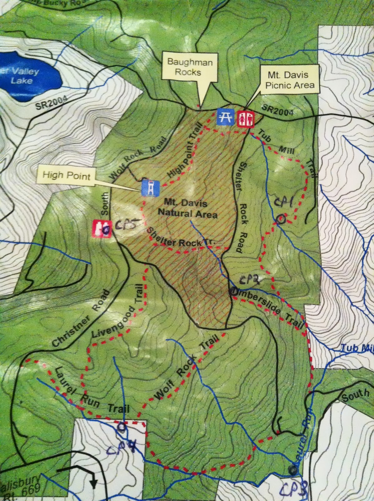
The rail trail on our bikes was much quicker and nicer than on our feet... On the way to CP19-20/TA8-9 our rhythm was not as steady as it should have been as we searched a bit for CP18 as it was not were we expected it to be... and of course we had to stop to inflate tires a few times and also pick up water. After climbing up to 3120' feet we finally got to Mt Davis area for the last trek. We received a new map with the next set of CPs called ‘MD’ this time for ‘Mt Davis’. We were pretty relaxed but we made a quick TA. We set out clockwise. MD4 proved to be more challenging than expected but beside that we had a great trek working really well as a team again. JY and I exchanged the nav a bit again which gave me a bit of a break, he did a great job. We ended the trek with a fantastic red sunset, beautiful!


We picked up our bikes at CP20/TA9 and took a few minutes to discuss with race staff (same race staff we had seen pretty much all race!) as we were now good friends! We had mixed emotions when we learned that CP21 has been cancelled for safety reasons. With no one mathematically able to catch us, the organization decided to remove this last difficulty (a tough 6km dirt road uphill - same one we descended on route to CP14/TA5). We would have liked to tackle it, but at the same time riding the rail trail to the finish was very welcome by our tired legs... So off we went on the monstrous descent. Near the end Jo must have passed me at about 80km/h...! No need to say he was very happy to descend! We eventually caught up with the rail trail again with 30km to go. Spirits were very high !
We happily reached the finish around 12:15am. We had accomplished what we set out for 4 days before - winning the 2013 Equinox Traverse!
Debrief
Races provide the best opportunities to reflect on what we can do better to improve individually and collectively. So here are a few things we need to rethink after this race:
Cutting the map in smaller pieces: We should not be afraid to cut the map if it's too large. At some point I had to unfold and fold back on the bike descending at 40 km/h whitout holding my handle bars... what a silly risk. We should have taken the time to cut it in smaller pieces and number them appropriately. It also makes it much easier to make them water resistant (which is a must). My bad as I did this many times, I will next time for sure as it's much easier to manage, especially on the bike.
Trying the gear/bikes the night before: I am not sure how it happened, but we should have seen the problem on JY bike at least the night before. Try your gear setup before the start!
Take advantage of what is available out there: Many times we treated water, but could have had filled up our bottles from garden hoses or stores, private houses, etc. There is nothing wrong with treating water, but on the long run it can get harder on the stomach and as we (I...) often stretch the time before we fill up... the 20 minutes or so it takes for the water to be ready to drink is sometimes annoying.
In my mind there are 4 main ingredients that paved the way to our victory:
1. Preparation: We not only train hard, but we also make our best to ensure that no details slip away from us on the logistical side. I had around 50 maps of all sort and from the all the states parks within 50 km around Ohiopyle printed out. Also, we stayed in a house at walking distance from race HQ. We were able to cook, prepare the bikes and map the course in a relax environment. It could have rained, snowed or heeled, we would would have been ready anyway. Little details make a big difference.
2. Navigation on the course: Navigation is the name of the game. We will never emphasis enough on this. When you map out the course it often seems straight forward... but it never is. It seems we took the right turns at the right spot because we tracked time, direction and distance. There is no big secret, it's mathematical. It's really worth it to slow down for a few extra seconds to take the right trail/road/bearing and ensure you are stepping in the right way. We encountered many trails that were not on our maps, and many trails on our maps where no where to be found. This is when compass, time and distance are your best allies. And everybody can/has to contribute.
3. Constant movement : We kept a good pace pretty much all the way, helping each other to ensure the team was moving at maximum. We stopped only when necessary and made sure to coordinate to make the best out of our stops. No need to red line, just a constant speed to ensure we had gas for what was in from of us.
4. Racing with the cut-off in mind : Probably what made a big difference in this race. As mentioned there was a cut-off to be respected to ensure we could keep racing on the full course. On the first trek, we deliberately (but not happily...) skipped a CP (QR5) to make sure we would arrive on time at the bike/kayak TA. We had done the maths and knew how much time we needed to be back on time with a small buffer. Turned out our rivals did not/could not make it, and the game was pretty much played after that. Cut-off are very important and there was a lot of race left after, so we were less concerned about leaving a CP behind than not making the cut-off.
Thanks to Doug, his staff and all volunteers for their warm welcome and great job. Best of luck with the Maya Mountain Adventure Race, it is set to be a fantastic adventure! It’s on our long list for sure!
Congratulations to all racers. This was a tough race. Can’t wait to compete with you guys again. AR is the best sport, get the word out and bring some friends!
Thanks to our partners Untamed New England, Clinique du pied Équilibre, Icebreaker for great adventure clothes and make us look good, Nuun hydration to help us stay sharp all race long, Osprey packs, Thule, Rollerblade, Suunto for the best navigation tools, Light in Motion for awesome lighting system, Swiftwick for compression socks, Julbo eyewear and Fruit2.
See ya on the trail!
Alex


.jpg)